Each year 1854 partners with the Minnesota Department of Natural Resources (DNR) and Fond du Lac Band (FDL) to survey the moose population in the Arrowhead. The survey began in the early 1970’s to monitor the trends in moose population, whose range almost overlaps the 1854 ceded territory entirely. Each year the survey is flown with DNR helicopters and is targeted to start the first working day in January if snow conditions are suitable (ie, snow provides a nice white backdrop to see moose).
How the Survey is Conducted
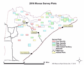
The entire range of moose in Northeastern Minnesota is broken into three-by-five (3x5) mile survey plots, and these plots are then categorized by expected moose density. In a low density plot we would anticipate seeing no more than two moose. Three to seven moose are likely to be roaming a medium density plot. Eight or more moose define a high density plot. Annually, approximately 45 plots (which is about 10% of the total moose range) are randomly selected to be surveyed. Results from those survey plots are used to calculate a population estimate. At the end of the survey we have an average number of moose observed for each category, which is then applied to the total area of moose range within that category. The sum of these averages gives us the range-wide estimate for ceded territory moose.
Looking at Habitat Too
In addition to the population survey, in 2011 the survey crew began flying nine habitat plots every year as well. These habitat plots are located where management is focused on creating and maintaining moose habitat. They include areas burned in wildfires (Cavity, Ham, Pagami), areas being managed with prescribed fire, and areas with timber management focused on creating and maintaining moose habitat. Hopefully surveying these habitat plots annually will shed some light on the most beneficial means of creating moose habitat and how quickly they respond to those efforts.
Check out the results of the 2016 AERIAL MOOSE SURVEY