
During a ten-day period in early July, program partners and volunteers take to over 600 lakes throughout Minnesota to observe Maang. Adult and juvenile loons are counted to analyze reproductive success and the data is reported to the Department of Natural Resources (DNR) for a population analysis.

The Minnesota DNR has coordinated this Loon Monitoring Survey for over 20 years.

Ceded Territory lakes surveyed by 1854 Treaty Authority during 2015:
Elbow, Lost, Organ, West Twin, Green Wing, Mit, Frear, McDonald, Timber,  and White Pine

See the DNR's LOON SURVEY WEBPAGE

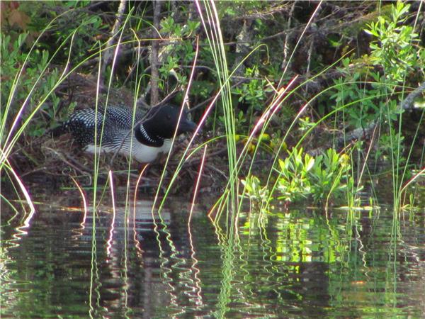
This nesting loon was spotted by Invasive Species Technician, Jeffrey Flory, during the 2015 Loon Survey.

The Minnesota Department of Natural Resources (DNR) has two surveys designed to track population trends in animals whose fur is valued commercially. Both furbearer surveys are run across much of Minnesota and the species encountered vary depending on where in the State the survey route is. It is valuable for 1854 to participate as a number of Band members actively pursue fisher and pine marten trapping each fall.

Scent Post Survey

The Scent Post Survey is run in early fall and consists of ten stations placed along gravel or dirt roads that serve as frequently traveled routes for many wildlife species. Grass, leaves, and gravel is cleared from a 3-foot diameter circle at each station. Fresh dirt is then sifted over the station as a good track medium and the center of each station is baited with a very smelly disc. The following day the route is checked and the tracks of visiting furbearers are identified and counted. 

Winter Track Survey 

The Winter Track Survey is conducted after a fresh snowfall and consists of a ten-mile route along a roadway or trail where furbearer tracks are identified and counted in each half-mile segment. Along the routes that 1854 coordinates, our most common visitors are fisher, pine marten, red fox, wolf, and coyote.

See the DNR's 2012 MINNESOTA SCENT POST AND WINTER TRACK SURVEY SUMMARY.

Tracks of the elusive Canada Lynx identifyed during Winter Track Survey

In autumn every year 1854 Treaty Authority coordinates a small mammal survey. The purpose of the survey is to monitor trends in annual abundance of small animals like mice, voles, and shrews that are important in the diets of predators like fisher, pine marten and owls. A number of cooperators ranging from other natural resource management agencies to schools and private individuals participate in collecting information on small mammal abundance across Northern Minnesota. Sixty traps, baited with peanut butter, are set across three transects consisting of ten stations each (2 traps per station). Traps are checked for two consecutive days, and every capture is identified and counted.

How the Data is Used

An abundance index is created by calculating the average catch rates for each species. This abundance index can be compared to abundance information for furbearers like fisher and pine marten. There appears to be fairly good correlation between years of abundant small mammals in the woods and good numbers of juvenile fisher and pine marten in the fall trapping harvest, highlighting the importance of a good prey base to these furbearer species.

You must be sneaky biologist to find a nest of Red-backed voles! Females can have 2 to 3 litters a year, and litter size ranges from 3 to 7 young.

Drumming is performed by “cocks” or male ruffed grouse as a means to defend territory. In the spring, drumming becomes more frequent and it is used to court females, or “hens”.

 –audio clip, provided by the Ruffed Grouse Society

1854 Resource Management staff participate in a survey each spring to monitor ruffed grouse population trends. Coordinated by the Minnesota Department of Natural Resources (DNR), the survey is made possible by many cooperators across the state.

How the Survey is Conducted

The survey procedure is fairly simple. Each year, shortly before the woods start greening up we drive an established ten-mile survey route. At every mile the survey vehicle is stopped and shut off, and participants get out to spend four minutes listening for, and counting, drumming male grouse. The data is then returned to the DNR where they compare drumming rates from year to year to ascertain trends in the grouse population. Interestingly, ruffed grouse numbers appear to cycle over time with peak populations occurring roughly every ten years.

See the DNR's MINNESOTA SPRING GROUSE SURVEY REPORT, 2015.

Environmental Director Darren Vogt nabbed a shot of this Ruffed Grouse around the Twin Lakes area during the annual survey.

Each year 1854 partners with the Minnesota Department of Natural Resources (DNR) and Fond du Lac Band (FDL) to survey the moose population in the Arrowhead. The survey began in the early 1970’s to monitor the trends in moose population, whose range almost overlaps the 1854 ceded territory entirely. Each year the survey is flown with DNR helicopters and is targeted to start the first working day in January if snow conditions are suitable (ie, snow provides a nice white backdrop to see moose).

How the Survey is Conducted

The entire range of moose in Northeastern Minnesota is broken into three-by-five (3x5) mile survey plots, and these plots are then categorized by expected moose density. In a low density plot we would anticipate seeing no more than two moose. Three to seven moose are likely to be roaming a medium density plot. Eight or more moose define a high density plot. Annually, approximately 45 plots (which is about 10% of the total moose range) are randomly selected to be surveyed. Results from those survey plots are used to calculate a population estimate. At the end of the survey we have an average number of moose observed for each category, which is then applied to the total area of moose range within that category. The sum of these averages gives us the range-wide estimate for ceded territory moose.

Looking at Habitat Too

In addition to the population survey, in 2011 the survey crew began flying nine habitat plots every year as well. These habitat plots are located where management is focused on creating and maintaining moose habitat. They include areas burned in wildfires (Cavity, Ham, Pagami), areas being managed with prescribed fire, and areas with timber management focused on creating and maintaining moose habitat. Hopefully surveying these habitat plots annually will shed some light on the most beneficial means of creating moose habitat and how quickly they respond to those efforts.

Check out the results of the 2016 AERIAL MOOSE SURVEY